
Hiking the Grand Canyon: South Rim to Phantom Ranch and back!
- Sandra Meyer
- Jul 23, 2020
- 7 min read

All I wanted for my birthday this year was for my husband to hike Rim to Rim in the Grand Canyon with me. He said yes! It was January, and I tried to book hotel rooms for late May....turns out that was too late!
The North Rim was all booked, but I managed to get us in for late June. It wasn't optimal as we knew it would be pretty hot by then (really, really, really hot), but we decided to go for it anyway. Then COVID 19 hit, and the Grand Canyon closed. Like everybody else, we took a deep breath and accepted that no meaningful travel would happen in 2020.

What happened after that was a roller coaster of "it's happening" and "it's not happening" (North Rim stays closed due to the pandemic, North Rim reopens, East Entrance still closed (access way to the North Rim), shuttle service to the North Rim opens, shuttle service closes down again (which means no ride to the North Rim), fire on the North Rim, North Rim closes again, etc).
So instead of giving up we decided to adjust our plans. The Rim to Rim hike would have been a 24 mile hike via the famous Phantom Ranch. We figured we could still have a great hiking experience by descending down the South Kaibab Trail to Phantom Ranch for 7 miles and returning back up via the Bright Angel Trail for 10 miles ( which is the trail we would have taken on the Rim to Rim as well). The North Kaibab Trail would simply have to wait until things got back to something more normal. This hike would be very challenging and have fantastic views....the Rim to Rim could be saved for a better year!

We cancelled our night at the Grand Canyon Lodge on the North Rim and replaced it with another night at the El Tovar Lodge on the South Rim. And as an additional bonus: our dear friends Chris and Shannon decided to join us on the adventure!
Our packing list would pretty much stay the same: lots of water storage, instant ice packs for our heads, electrolytes and trail mix. We also brought headlamps, a water sterilization pen, water sterilization tablets, and Shannon had cooling towels which ended up being total life savers.
The entire adventure turned out to be challenging, hot, and absolutely stunning!

Here are some details about the trail, what to look out for and how to plan for this hike. The entire hike is 20 miles long with an elevation difference of 4,500 feet between the South Rim and the Colorado River. I am dividing the whole trail into major milestones:
Mile 0 (Starting Point): Street Parking before the South Kaibab Trailhead
You cannot park at the South Kaibab Trailhead. Usually the shuttle will get you there, but right now the shuttles are not running because of COVID 19. There are three official parking lots on the way to the trail head, but if you keep going past them you will also find street parking that gets you to within 1 mile of the trail head. Just know that at the end of the day you will have to get your car back, as the end of our route was five miles further west than the beginning. It really only works if you have two cars (without the shuttle service).

Mile 1: South Kaibab Trailhead
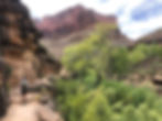
This is where the fun began. Before we even got there, we saw deer. There was a bathroom at the trailhead and plenty of photo opportunities. The beginning of the trail was really the most beautiful part of the entire hike, especially at sunrise. I am so glad we chose this route and started as early as we did! Starting at approximately sunrise rewards you with the best light (picture golden, glowing rocks) and more bearable temperatures. I kept taking photos of the trail itself, as it is carved into the side of the canyon. On some of the photos it gives the impression that there is a scary, steep drop....I guess there really is, but it was not scary at all (and this is coming from the hiker who is afraid of heights).


Mile 8: End of South Kaibab Trail
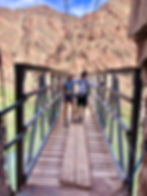
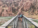
Descending down the South Kaibab Trail was pretty hard on the knees, but very beautiful. You pass Ooh-Aah Point and Skeleton Point, both of which yield fantastic views. After some more time you will have your first views of the Colorado River as well, and eventually you cross the Black Suspension Bridge to the other side of the river.
On the entire trail there was no water station or bathroom, so you have to come well prepared if you hike this trail, especially if you choose this as your return route as well.


Mile 9: Phantom Ranch
After you cross the Black Suspension Bridge you can immediately join the Bright Angel Trail to return to the South Rim, but we decided to make the detour to see Phantom Ranch. It's an additional mile in each direction, but it was worth it: ice cold Arnold Palmer (my first one ever!) and an air conditioned bathroom, which felt like heaven after hours in the heat. At that point the temperature had reached more than 110 degrees.
There was a water filling station at Phantom Ranch and we received conflicting information as to whether the water was safe to drink or not. At the ranch we were told to drink it, but after using the SteriPen we knew it wasn't advisable. I filled another Arnold Palmer into my water reservoir (let's face it: it's called a bladder, and I am only avoiding the term because it grosses out my kids), thanked the SteriPen and we were on our way back.


Mile 10: Bright Angel Trailhead
After the same mile back we reached the Silver Suspension Bridge over which we crossed back to the south side of the Colorado River. This was also a great spot to hop into the river without being exposed to the rapids. Because of the heat a ranger had advised us to soak our shirts in the water and put them back on wet to keep our bodies cool. This was the first time during the hike that we did this, and it ended up being the absolute best. Cooling towels also helped tremendously. From this point on it was ten miles up!

Mile 15.5: Indian Gardens
Only 4.5 miles to go now, but to get to this point we had to tackle the switch backs called the Devil's Corkscrew. This part of the trail is beautiful but also very exposed and hot. We soaked our T-Shirts in the creek as often as we could on this part and also got out the icepacks and the cooling towels. It was hot! To make it more exciting this was also the part where I ran out of water (1.25 gallons), because we couldn't properly refill at Phantom Ranch. It really had me panic to think that I might have to rely on my friends' water, but I made it to Indian Gardens and refilled all I had with me: one gallon of water storage! Not enough! Note for next time!!!! (I only drank a third of a gallon during 15 hours of hiking Whitney....totally underestimated the heat!)

Mile 17: 3 Mile Rest House
As the name suggests: you are now three miles from the rim, the trail starts getting more crowded with people that are doing shorter hikes from the rim. On a good note: you have water and an emergency phone here should you need it.
Mile 18.5: 1.5 Mile Rest House
To get here, it's just more of the same. I found that the views didn't change much during this part and you are starting to get really tired and mentally exhausted. But again: this is the trail that caters to the "casual" walkers close to the rim, so there will always be water and a phone, and that's a good thing.


Mile 20: The End
The final stretch was the steepest portion of the hike but not the hardest. At this point the sun was starting to set and the heat had lost its bite. Plus: we could almost smell the cold beer that was waiting for us on the patio of the El Tovar Lodge. Just before the end of the trail you walk through a little arch and you know you made it!

In summary:
Overall this was a great hike: challenging trails, fantastic views and at the end a sense of accomplishment. Between the two trails we took, our entire group agreed that the South Kaibab Trail is much more beautiful and less crowded than the Bright Angel Trail. It's steeper (same elevation gain but only 7 miles instead of 10 miles long), and there are no water stations along the way. Unless you carry at least 2 gallons of water with you, I would not recommend taking this trail. But: to lighten the load you could always stash some water on the way down and pick it back up on your return.....
I will admit: the heat was tougher than I had expected. Two days before we hiked, a woman my age died on her way down the Canyon from heat exhaustion. The weekend before, 23 people had to be rescued. Each year, approximately 250 hikers get into serious trouble and have to call for help.
Don't take this hike lightly! Make sure you train before you go and take enough water. Every person in our group drank between 2 and 3 gallons of water. Add electrolytes! Water alone will not replenish what you lost. Bring enough food! Don't bring bars with chocolate (like I did): they turn into something disgusting and slimy by the time you open them. Trail Mix and jerky were great options, sandwiches also worked. And whatever you decide to wear (this one is for the girls): make sure you can take your T-Shirt off and soak it in the creek or river!

This hike takes between 11 and 13 hours, depending on how fast you walk and how many breaks you build in. If I did it again, I would probably plan for a loooooong lunch break during the hottest hours of the day and target a later but cooler return. Alternatively, you can enter the lottery for a night's stay at Phantom Ranch. The lottery happens 15 months before your actual stay date, so plan ahead.

Next year the REAL Rim-to-Rim!!!!
Please contact me for any questions!
Cheers,
Sandra
*Note: As an Amazon Associate I earn a small fee from qualifying purchases through one of my links.